Fly-By Forestry Takes Off
By Catherine Clabby
Remote laser imaging can measure the health and density of forests, allowing scientists to observe large swaths of vital ecosystems all at once.
Remote laser imaging can measure the health and density of forests, allowing scientists to observe large swaths of vital ecosystems all at once.

DOI: 10.1511/2015.112.23
Despite some scattered recent gains, the world’s forests are in trouble. From 2000 to 2012, the planet lost a net total of 1.5 million square kilometers of forestland, according to a 2013 survey based on NASA satellite data. Much of the decline was due to deforestation in Brazil, Indonesia, and other tropical countries, but there have been many other setbacks as well. In the western United States, for instance, trees face an onslaught of wildfires, insect infestations, and drought. The assaults persist despite a growing awareness of the ecological value of forests, particularly their ability to absorb large amounts of carbon dioxide and sequester carbon.
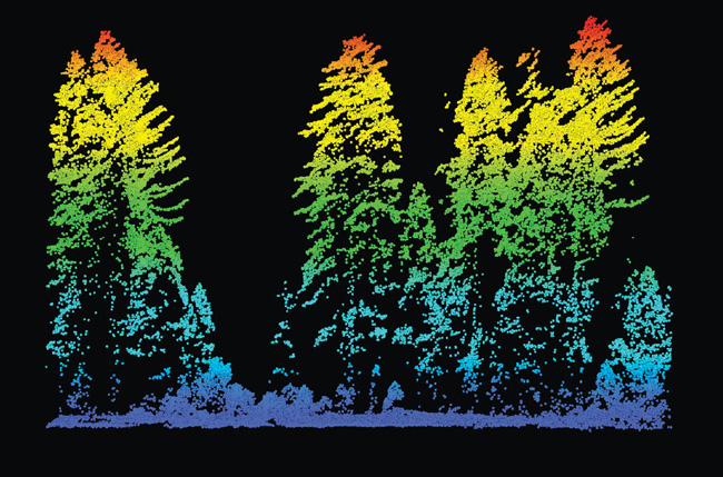
Image courtesy of Van Kane of the University of Washington and Robert McGaughey of the US Forest Service.
As they formulate ways to protect endangered woodlands and rehabilitate ones already lost, scientists and governments need detailed information on the structures and vulnerabilities of forests around the world. Traditional ground-based surveys lack sufficient scope, so scientists are turning to another way to take the measure of the trees: light detection and ranging, or LiDAR, remote-imaging technology. Airplane-borne LiDAR scanners shoot 100,000 pulses of laser light per second to record the distance to the ground. From those data, researchers can measure the shape, type, and density of forest cover over tens of thousands of square kilometers. “That is the real power of LiDAR,” says Van Kane, an ecologist at the University of Washington who uses the technique extensively. “We can build tremendously large databases.”
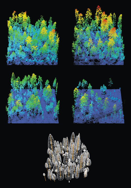
Image courtesy of Van Kane of the University of Washington and Robert McGaughey of the US Forest Service.
In one notable recent study, Kane and his colleagues used LiDAR to observe how fires of various intensities affect the forests in Yosemite National Park. Some fires are known to help keep forests healthy by creating gaps in their canopies that enable new growth. Kane’s LiDAR-based studies show more specifically that low- severity fires produce favorable density changes in areas dominated by red fir forests, but fires of moderate severity are needed to improve areas dominated by ponderosa and white fir–sugar pine trees. Kane has also combined airborne LiDAR with satellite vegetation data to study how natural fires alter tree density of Yosemite forests. They do so in more irregular ways than was previously known, creating variable mosaics of tree clumps. Those studies will aid forest managers designing controlled burns or mechanical thinning to mimic natural fire’s positive effects.
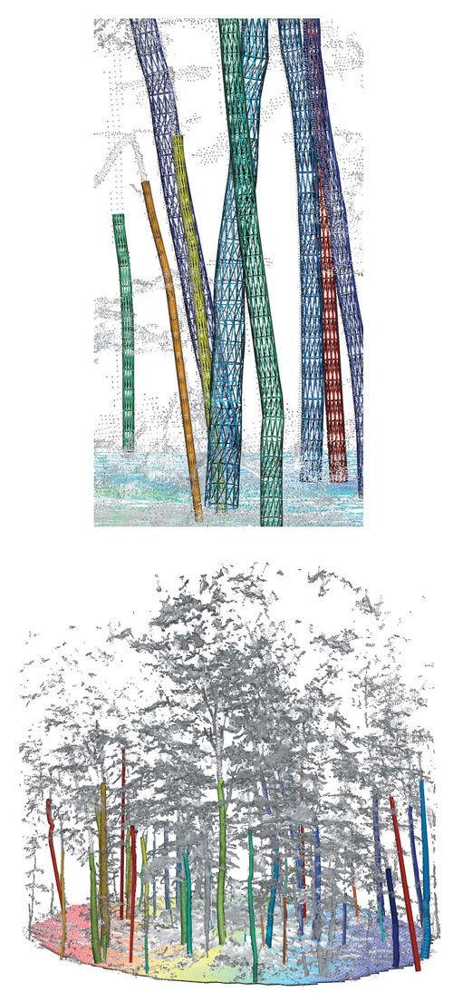
Image courtesy of David Kelbe at Rochester Institute of Technology.
Now the drive is on to make LiDAR even more useful. For instance, airborne LiDAR discerns only modest amounts of detail below the outer canopy in dense forests, so researchers are trying to fill the gap by adding measurements made with ground-based LiDAR. David Kelbe, a doctoral student in imaging science at Rochester Institute of Technology, recently adapted an industrial LiDAR device to create a portable scanner that can be carried into the woods. There, it can be used to acquire diameter data along the full length of tree trunks with enough detail to model three-dimensional trees. Such data could be useful for commercial forest inventories and for habitat studies, and also for calibrating across the different types of LiDAR studies. “We could take advantage of the fine-scale resolution by linking it to the large geographic coverage by an airborne or space-borne platform,” Kelbe says.
Carnegie Airborne Observatory earth scientist Greg Asner merges up-close and remote observations to get as near as possible to ground truth in tropical forests. He creates carbon maps, geographically accurate models depicting the density of vegetation in the forests; the more abundant the vegetation, the more carbon is sequestered in its roots, stems, and leaves.
To build these maps, Asner combines airborne LiDAR data with non-LiDAR research plot observations, rainfall records, and space-based measurements. By developing algorithms to extract high-resolution vegetation maps from archival data taken by the Landsat satellite, he quickly acquired a vast—and free—satellite data set.
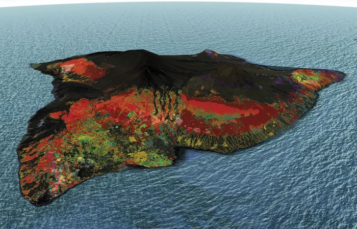
Image courtesy of Greg Asner.
Following this approach, Asner has mapped large swaths of the Amazon River basin, Peru, Panama, and Hawaii to pinpoint where carbon sinks most urgently need protecting. He feels the urgency of his work: It can take decades to rebuild a damaged forest into a carbon sink, but almost no time at all to cut or burn a forest down. “So we integrate satellite data with the airborne LiDAR in order to scale up,” Asner says. “This helps to greatly reduce cost and improve our speed.”
Click "American Scientist" to access home page

American Scientist Comments and Discussion
To discuss our articles or comment on them, please share them and tag American Scientist on social media platforms. Here are links to our profiles on Twitter, Facebook, and LinkedIn.
If we re-share your post, we will moderate comments/discussion following our comments policy.