Reef Health from Space
By Fenella Saunders
Satellite imaging of sediment formations could be a proxy for coral productivity in a changing climate.
Satellite imaging of sediment formations could be a proxy for coral productivity in a changing climate.
The Great Barrier Reef in Australia is a beautiful place for scientists to visit, but field studies cannot be conducted frequently enough to provide the extensive data needed to monitor coral reefs for signs of stress from climate change. So geoscientist Ana Vila-Concejo of the University of Sydney and her colleagues turned to satellite imagery to see if they could establish any visual measurements that correlated to coral reef health over time. They focused in on what are called sand aprons, formations caused by waves pushing sediment into lagoons at the centers of coral reefs.
Healthy coral reefs produce carbonate, the mineral that builds up the coral and the shells of other tiny organisms living on the reef. Carbonate is broken down by waves, or sometimes digested by some fish, to become sand. Waves that wash over the reef carry this sand into the central lagoon, creating a formation that stretches into the apron-like shape. The extent of the sand apron, and its growth over time, therefore relates back to how much carbonate the reef forms, which is an indication of how productive and healthy it is, Vila-Concejo says. “Basically, a coral reef is typically like a bucket; it has a hole inside and tends to trap sediment in there. So the water flow tends to accelerate over the reef and picks up all of this carbonate produced, and moves it,” she explains. “As it hits the deeper water, the flow decelerates and drops whatever it is carrying. So the paradigm is that these buckets will fill in over time, but the story is not just as simple as that. It depends how much waves, water, and sediment you have. Not all reefs will infill.”
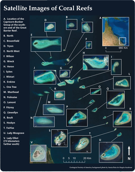
Geological Society of America; background photo by Amaia Ruiz de Alegria-Arzaburu; higher resolution version
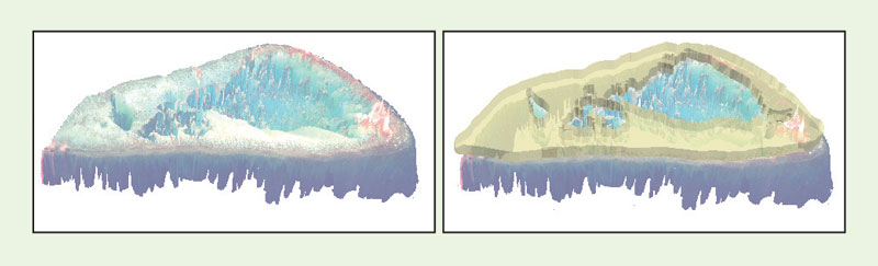
To measure reef sand aprons, Vila-Concejo and her colleagues had to do far more than just look at satellite images. The team started with images of a chain of 21 coral reefs in Capricorn-Bunker Group on the southern end of the Great Barrier Reef (see above; background image shows part of the sand apron of One Tree Reef). They combined these images with extensive data from previous fieldwork studies their team had done at these reef sites to map the seafloor, creating what’s called a digital bathymetric model (as shown in the left-hand image below for One Tree Reef). The team then manually digitally outlined the contours of the sand aprons of each of the reefs in this study. Combining these two models gave them a visual estimate of the sand apron infill area and volume for each reef (as shown in the right-hand image below for One Tree Reef).
As the team reported in the October 11, 2022, issue of the journal Geology, they estimate that the Capricorn-Bunker Group produces between 1.8 and 2.66 kilograms of carbonate per square meter per year, or about 659,000 metric tons per year across all 21 reefs. The individual reefs varied widely in their carbonate production, ranging from less than 0.5 kilograms per square meter per year, to 2.83 kilograms per square meter per year. Larger reefs, they found, were typically less filled in, and larger tidal ranges at certain locations may also affect the rate of sediment transport. Local structures, such as the width of the reef flat or the presence of tidal channels, can also be a factor.
Taking One Tree Reef as an example shows the data’s complexity. Vila-Concejo has data from a 2009 tropical cyclone that shows that the sand apron at One Tree Reef wasn’t extended even by that extreme event, indicating that the maximum sediment transport distance for the reef has already been reached. There is also some conflicting geological evidence, Vila-Concejo says, that about a half-meter sea level drop occurred about 4,000 years ago for unknown reasons, cutting off the reef from ocean sedimentary processes. Accounting for all these factors, the team was still able to calculate historical carbonate productivity for the reefs from when they formed about 8,000 years ago to about 4,000 years ago. For One Tree Reef, they estimated its historical productivity to be about 4.72 kilograms per square meter per year, or about twice the present-day average.
The team’s results suggest that reef production may already be suppressed by climate change, even though this formation is currently reasonably healthy. “Over the next 20 or 50 years with sea level rise, the transport capacity will be increased, but will we have enough sediment for those waves to move, because of the health of the reef?” Vila-Concejo asks. “Satellite imagery is helping us scale up our findings. We still need to go to the field and do ground-truthing, but satellite helps us have a longer, more continuous record spread over larger areas.”
Click "American Scientist" to access home page
American Scientist Comments and Discussion
To discuss our articles or comment on them, please share them and tag American Scientist on social media platforms. Here are links to our profiles on Twitter, Facebook, and LinkedIn.
If we re-share your post, we will moderate comments/discussion following our comments policy.