The New Wealth of Nations
By Amos Esty
Does Bhutan have a better way to measure national progress?
Does Bhutan have a better way to measure national progress?

DOI: 10.1511/2004.50.0
Happiness is no laughing matter in Bhutan. In 1972, the king of the tiny Himalayan nation declared that his country's development should be measured not by purely economic indicators such as gross national product (GNP), but by gross national happiness (GNH).
Barbara Aulicino
Much has changed in Bhutan over the past three decades, thanks in part to the encroachment of Western culture through television and, more recently, the Internet. But the nation maintains its unconventional yardstick of success. The prime minister frames his annual report to the National Assembly in terms of progress toward the "four pillars" of GNH: "the promotion of equitable and sustainable socio-economic development, preservation and promotion of cultural values, conservation of the natural environment, and establishment of good governance."
Bhutan, say an increasing number of psychologists and economists, may have a point. Economic measures such as GNP and the more widely used GDP (gross domestic product) after all, have many "blind spots." They fail to take into account factors such as volunteer work, the value of vacation and leisure time or the loss of natural resources due to environmental degradation. Last February, more than 300 academics, journalists and students enthusiastic about GNH gathered in Bhutan's capital of Thimphu to spread their message. As the title of one paper put it, it was "A Good Time for Gross National Happiness."
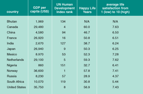
Ruut Veenhoven, a psychologist at Erasmus University in the Netherlands who attended the conference in Thimphu, has dedicated much of his career to studying measures of life satisfaction and believes that eventually such indicators will replace GNP. By combining surveys of life satisfaction with life-expectancy rates, Veenhoven has devised what he terms "Happy Life Years" (HLY) to measure levels of well-being across countries. In Canada, for example, where the life expectancy is 78.6 and the average level of life satisfaction is 7.63 on a scale from 1 (low) to 10 (high), the average HLY would be 60 (78.6 × 0.763).
Ed Diener, a professor of psychology at the University of Illinois at Urbana-Champaign, also takes happiness quite seriously. With positive-psychology pioneer Martin Seligman, Diener published an article in the July 2004 issue of Psychological Sciences in the Public Interest arguing that "well-being should become a primary focus of policymakers." The paper concludes that more accurate measurements of national progress would include three approaches: economic indicators such as GDP, social indicators such as education and healthcare, and more subjective measurements that reflect levels of life satisfaction. As they point out, GDP per capita has tripled in the United States since World War II, yet life satisfaction rates have remained static.
Diener believes that "experience-sampling" is necessary along with surveys to get a clearer picture of levels of well-being. In such samples, individuals record their feelings about work, family and other important aspects of life periodically throughout the day for an extended period of time. The authors admit that making such research part of national policy would be expensive, but say that the costs would pale in comparison to the money spent measuring economic indicators. Plus, citing studies showing that happy employees are generally healthier and more productive than employees with lower levels of well-being, they argue that higher levels of well-being could be a boon to the economy.
Economists working to measure GDP need not worry about job security just yet. "A huge shift in the way policymakers think" would be required, Diener concedes, for new measures of development to be implemented, and Veenhoven notes that data on life satisfaction simply are not available for many countries, including Bhutan.
Fittingly, though, Diener and Veenhoven remain optimistic about the future of their field. Although Diener does not think that well-being will, or should, replace GNP entirely as the primary indicator of progress, he can envision a day when well-being statistics flit across television screens next to stock-market updates. What's needed, both say, is a good set of numbers backed up by research. After all, says Diener, "if you want people to pay attention to something, measure it."—Amos Esty
Click "American Scientist" to access home page
American Scientist Comments and Discussion
To discuss our articles or comment on them, please share them and tag American Scientist on social media platforms. Here are links to our profiles on Twitter, Facebook, and LinkedIn.
If we re-share your post, we will moderate comments/discussion following our comments policy.