Serious Nonsense
By Anna Lena Phillips
Edward Lear’s natural-history illustration won him scientific credibility. Now his nonsense verse may do the same.
Edward Lear’s natural-history illustration won him scientific credibility. Now his nonsense verse may do the same.

DOI: 10.1511/2013.100.28
“How pleasant to know Mr. Lear,” begins one of Edward Lear’s poems. His bicentennary last year helped many people know him better, with multiple exhibits of his natural-history paintings and drawings.
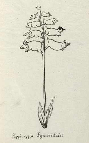
Image courtesy of Houghton Library, Harvard University. MS Eng 797.1 [20]
Lear gained acclaim as an illustrator at age 19 for his work on parrots. Shortly thereafter, The Earl of Derby invited Lear to his estate near Liverpool to make portraits of specimens in his vast collection of exotic animals and plants. “Lear was somewhat lonely at Knowsley Hall,” says Robert Peck, a Lear scholar and senior fellow of Drexel University’s Academy of Natural Sciences in Philadelphia. “He was overwhelmed at times by the English social class structure.” To overcome this, he began making drawings and verses for the Earl’s grandchildren. Later he published the verses, but he used a pseudonym for many years. “He was concerned that the frivolous nature of his limericks would undercut his credibility as a scientific illustrator,” Peck says.
Those verses have recently come to seem a bit less frivolous. Margaret Wallace Nilsson, now a Ph.D. candidate in history at Linnaeus University, took up the question of how Lear’s poems might help children learn. “All children like repetitive rhyme sounds,” she says. “I thought, why not apply this to Swedish students of English? It might help them improve their pronunciation and, later on, be able identify new words with the same phonetical patterns.” In a 2011 master’s thesis for the School of Teacher Education at Kristianstad University in Sweden, Nilsson taught a control group of fourth graders a list of vocabulary words taken from Lear’s Nonsense ABC. An experimental group was asked to learn verses from it. “The children in the second group not only learned to recognize the phonetical sounds of the verses, but actually started to spontaneously rhyme other English words,” she says. When tested, students in the second group remembered words from the verses better. Nilsson thinks nonsense poems may help adult language learners as well. And she’s not alone in her interest. In 2012, Juliette Smeed of New Zealand Tertiary College in Auckland published an essay in He Kupu, an early childhood education journal, describing types of nonsense verse and discussing strategies for responding to children’s nonsense play.
Lear’s poetry and sketches often employed the scientific knowledge he cultivated for his “serious” work. Peck points to Lear’s “Nonsense Botany” series. “He’s playing with the Linnaean binomial nomenclature, the form of the flower and people’s love of flowers,” Peck says. “He could take this very serious scientific world in which he traveled and turn it literally upside down and make it fun for kids—and for everyone.” If Nilsson and others are right, Lear’s upside-down world may have more to offer than just fun.
Click "American Scientist" to access home page

American Scientist Comments and Discussion
To discuss our articles or comment on them, please share them and tag American Scientist on social media platforms. Here are links to our profiles on Twitter, Facebook, and LinkedIn.
If we re-share your post, we will moderate comments/discussion following our comments policy.