Mosquitoes’ Hothouse Potential
By Jameson Blount
A warmer climate may not limit the habitat range of these disease vectors.
A warmer climate may not limit the habitat range of these disease vectors.
Lisa Couper and her team have gotten very good at seeking out trees with broken branches, because the scars left behind create rain-filled holes that harbor mosquito larvae. Couper, a postdoctoral researcher in environmental health science at the University of California, Berkeley, and her colleagues have been collecting mosquitoes from these tree wells across California and Oregon. Their goal has been to determine whether mosquitoes can rise to the challenge of climate change. And their results so far show that mosquitoes can survive hotter conditions, allowing them—and the diseases they spread—to expand their territories beyond what experts previously thought possible.
“There’s a lot of effort and interest right now in projecting how mosquito-borne diseases will shift with changing temperature,” Couper says, “and virtually none of those projections incorporate the potential that mosquitoes will adapt to warming.”
According to the World Health Organization, mosquito-borne illnesses collectively cause nearly one million deaths each year worldwide. But their distribution is limited primarily by the temperature ranges that mosquitoes can tolerate. All current models of the spread of mosquito-borne disease assume that, with climate change, the diseases will expand into some areas—but withdraw from others that begin to exceed the existing thermal limits of mosquitoes. However, Couper and her team have demonstrated that mosquitoes have the potential to adapt to a warmer world, allowing them to expand their ranges with none of the withdrawal.
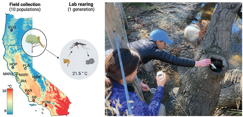
Couper, L. I., et al., Proceedings of The Royal Society B 291:20232457; Courtesy of Lisa Couper
To tease out the adaptive potential of mosquitoes, Couper and her team needed to isolate a single population and then subject them to different kinds of heat. The researchers chose to avoid working with the most infamous species of disease-carrying mosquito, Aedes aegypti, because it would have been a logistical nightmare to ensure they were contained and controlled. According to Couper, “They’re invasive, they’re not a native species here, and they’re human disease vectors.” So that’s why Couper and her colleagues were poking around tree wells for months, to shop local for their mosquitoes. They settled on a native species, the Western tree hole mosquito (Aedes sierrensis), for the artificial heat selection experiments.
All current models of mosquito-borne disease assume that, with climate change, diseases will withdraw from areas that begin to exceed the existing thermal limits of mosquitoes.
How do researchers keep and feed so many bloodthirsty mouths? The team planned to use chicken blood to feed their mosquitoes, but the insects wouldn’t cooperate at first. Couper had to sacrifice blood, sweat, and tears to keep her mosquitoes alive—literally. “I was feeding hundreds to thousands of mosquitoes on my own arm, because I initially couldn’t get them to feed on the chicken blood. Thankfully, we got that to work out eventually, but that was probably the lowest point of this experiment.” After months in the field gathering the little bloodsuckers, the team could move on.
Once they had established a laboratory population of these mosquitoes, the team’s first step was to test and measure their mosquitoes’ heat tolerance. The initial starting population of mosquito larvae was split into two groups: one raised at a high temperature of 30 degrees Celsius to simulate the upper thermal limit of mosquito larva survival, and one raised at a control temperature of 20 degrees to simulate the hottest it gets for this species of larval mosquitoes in their natural habitat.
When the surviving mosquitoes from both temperature conditions hatched, the team then measured the heat tolerance of the new adults. The researchers stuck the mosquitoes in individual glass vials, dunked them in a warm water bath, and then recorded how long it took for each mosquito to lose motor functioning. This artificial form of natural selection using heat stress yielded unexpected results.
“We were trying to impose selection such that we’re selecting for higher heat tolerance, but what actually ended up happening was that the heat-selected group was less heat tolerant at the next life stage, which was super surprising to us initially,” Couper says. “I think that implies that there’s some interesting trade-offs in how organisms respond to prolonged heat stress and how they respond to short-term temperature extremes, both of which we know are expected components of climate change.” In other words, the mosquito larvae that survived the hotter temperatures may have done so by using up more of their own resources, costing them their fitness in adulthood.
Couper and her team took these results one step further, examining the genomes of their heat-stressed survivors to see if variation in their heat tolerance correlated with variation in their DNA sequences. Previous studies of mosquito adaptability had shown that a specific type of DNA variation was worth looking at: chromosomal inversion. This form of structural mutation occurs when segments of DNA break off from the double helix and reattach in the reverse orientation. The inverted regions often bring adaptive versions of genes with them. Sure enough, when the researchers examined the correlations, the mosquitoes that survived the hotter conditions were more likely to have those chromosomal inversions.
"I was feeding hundreds to thousands of mosquitoes on my own arm because initially I couldn’t get them to feed on chicken blood. That was probably the lowest point of this experiment."
To determine if mosquitoes could increase their heat tolerance in step with climate change, Couper and her team looked at the mosquitoes’ genomes in a different light. By plugging their experimental and genomic data into a simple mathematical model, they could estimate the rate of mosquito evolution and see how it compared with the projected rate of climate change. Couper explains: “If the rate of evolution exceeds the rate of climate warming, then the population might be able to persist. If the rate of evolution is lower than the rate of climate warming, then you would expect it to go extinct. Under most values informed by our experiment, the potential rate of evolution for mosquitoes is greater than the potential rate of warming.” Outpacing climate change means mosquitoes, and their deadly microbial contraband, will have access to more victims.
“I hope that other researchers will see this study as a wake-up call, that this is a question that we really need to address in other mosquito species, especially the ones that are most implicated in severe disease transmission,” says Zachary Popkin-Hall, a postdoctoral researcher in infectious disease epidemiology and ecology at the University of North Carolina at Chapel Hill.
Popkin-Hall was impressed by what the study authors did, as well as by their acknowledgement of what they didn’t do. Couper and her team stated several caveats to their findings, including that their model of the rate of evolution had to make some simplifying assumptions that don’t reflect the real world, and that higher temperatures would bring additional stressors such as wildfires and drought that mosquitoes are less equipped to handle.
Popkin-Hall grew up in Northern Virginia and vividly remembers the hundreds of dead crows left in the wake of another disease transmitted by mosquitoes, the West Nile virus outbreak of 2000–2001. “The fact that mosquitoes and the pathogens they transmit could have such a huge impact on the health of humans and other animals made a huge impression on me,” he said. He and Couper both agree that these results warrant research and attention from scientists and public health officials alike. Couper hopes to help people living in areas that were previously projected to become too hot for mosquito-borne disease transmission to realize the hothouse potential of these insects. “We don’t want to underestimate the potential future mosquito-borne disease risk,” she says. “In terms of public health, we need to keep on it with vector control, vaccine distribution, and public health messaging, even in those warmer areas of the mosquito distribution.”
Click "American Scientist" to access home page

American Scientist Comments and Discussion
To discuss our articles or comment on them, please share them and tag American Scientist on social media platforms. Here are links to our profiles on Twitter, Facebook, and LinkedIn.
If we re-share your post, we will moderate comments/discussion following our comments policy.