
This Article From Issue
September-October 2006
Volume 94, Number 5
Page 474
DOI: 10.1511/2006.61.474
Mountains from Space: Peaks and Ranges of the Seven Continents. Stefan Dech, Reinhold Messner, Rúdiger Glaser, and Ralf-Peter Mártin. 244 pp. Harry N. Abrams, 2006. $50.
For most of human history, mountains have been worshiped as the homes of gods or demons, simply accepted as being there or ignored completely. However, the big mountain ranges of the world—the Himalayas, the Alps, the Andes—have always held a special mystique and fascination for humankind. It was perhaps Hannibal's crossing of the Alps at the outset of the Second Punic War between Rome and Carthage from 218 to 202 B.C. that, at least for the Western world, sowed the seeds for further mountain exploration.
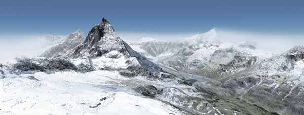
From Mountains from Space.
Ad Right
The modern age of mountaineering was ushered in by Jacques Balat and Michel Paccard, who made the first ascent of Mont Blanc in France in 1786. Edward Whymper subsequently conquered the Matterhorn in 1865. Since then we have seen Edmund Hillary and Tenzing Norgay climb Chomolungma (Mount Everest) in 1953 and a single person ascend the highest mountains on each continent (the "Seven Summits"); the first to do so was Dick Bass in 1985, followed by Pat Morrow in 1986. (On six continents, there is no difficulty in identifying the proper targets: They are Kilimanjaro in Africa, Denali [Mount McKinley] in North America, Elbrus in Europe, Aconcaqua in South America, Vinson in Antarctica and Everest in Asia; for Australasia, however, there is some controversy over which should be regarded as its summit—Carstensz Pyramid in New Guinea or Mount Kosciuszko in Australia. Bass climbed Kosciuszko and Morrow climbed Carstensz.)
For mountaineers, impressions of their surroundings during the climb and at the summit are always somewhat constrained by the viewer's perspective and in some cases also by clouds and storms. But Mountains from Space: Peaks and Ranges of the Seven Continents overcomes this limited ability to see the grandeur of the Earth's highest places. Working in collaboration with scientists at the German Aerospace Center, authors Stefan Dech (a professor at the Geographical Institute at the University of Würzburg), Reinhold Messner (a mountaineer), Rüdiger Glaser (director of the Institute for Physical Geography in Freiburg) and Ralf-Peter Märtin (a mountaineer and a freelance journalist in Frankfurt) have compiled an outstanding collection of satellite imagery. These views of individual peaks and ranges were obtained on various terrestrial observation missions. True to the title, the majority of the images have been prepared digitally from optical satellite data with a spatial resolution ranging from one kilometer to 60 centimeters. The majority of the images were obtained from satellites in space, but some of the views included are elevation models garnered from various high-flying aircraft or produced from digitizing maps.
The book also brings together an esteemed literary group of mountaineers, scientists and writers who contribute their thoughts and philosophy in a series of brief but illuminating vignettes on topics as diverse as plate tectonics, remote sensing via satellites, environmental and climatic change, spirituality, weather at high altitude, the details of individual climbs, and the cultural history of mountainous regions. These authors of these snippets include novelist Christoph Ransmayr; mountaineers Hillary, Messner, Märtin, Stephen Venables, Oswald Oelz and Alexander Huber; Dech, who works on remote sensing in cooperation with the German Aerospace Center; and geologist Glaser, who has provided informative introductory essays for each chapter.
The book's introduction is followed by six chapters that present imagery of the mountains of Europe, Africa, Asia, Australasia and Antarctica, North and Central America, and South America, in that order. A useful appendix provides information on which satellites were used to collect the data for each image, when the data were obtained and how they were processed, what the spatial resolution was of the satellite sensor, what organization processed the data, and a brief, but informative, description of the image.
As someone who has been a mountaineer and university scientist for more than 50 years, I found Mountains from Space fascinating and beautiful. Satellite imagery is an art form, and the book is a work of art. The pieces of text that accompany the pictures are clearly written for nonspecialists—that is, for people who are neither scientists nor mountaineers. Readers will obtain valuable insights into mountains and the men and women who climb them as well as a wealth of information on the geography, geology and cultural history of mountainous regions.

American Scientist Comments and Discussion
To discuss our articles or comment on them, please share them and tag American Scientist on social media platforms. Here are links to our profiles on Twitter, Facebook, and LinkedIn.
If we re-share your post, we will moderate comments/discussion following our comments policy.