This Article From Issue
July-August 2018
Volume 106, Number 4
Page 201
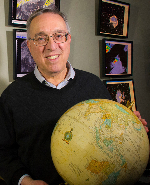
Lance Bosart, a distinguished professor of atmospheric and environmental sciences at the University at Albany–State University of New York, helped the field of meteorology to transition from examining weather at a local level to understanding it on a global scale. The data from observation centers around the world now form the basis of modern forecasting and atmospheric science. Bosart spoke about the past, present, and future of meteorology with American Scientist digital features editor Katie L. Burke as part of the Sigma Xi Distinguished Lecturers series. A video of the full discussion is available.

Photograph courtesy of the University at Albany
You’ve studied an array of weather and atmospheric processes since the 1960s. What was it about weather that captivated you initially?
Hurricane Hazel in 1954 produced the strongest wind gusts to this day ever measured in New York City. I was between 11 and 12, and I’d never seen it so windy, but it didn’t rain much. I said, “Why isn’t it raining? Hurricanes are supposed to have a lot of rain.” I asked my father, “Why isn’t it raining more? We’re having a hurricane.” He said, “I don’t know, go ask your mother.” So I asked my mom the same question, and she said, “Go ask your father.” That frustrated a little kid. It was only much later that I figured out why that was. When you start studying the field of meteorology, the rain’s on the left side of the track and the wind’s on the right side of the track when you have a storm at higher latitudes making landfall.
You have tackled some weather events and patterns that are difficult to predict. What was it that drew you to such a challenging area?
Well, I like to forecast every day. We have a forecasting contest during the academic year at school because you learn when you forecast. Out of forecast failures—and I’ve had probably close to Avogadro’s number of them in my career—come opportunities to learn what it is about the atmosphere in a particular case that leads to the forecast going off the rails. Science informs the weather forecasting, but equally important, weather forecasting informs the science. It’s a two-way street.
You have described the superstorm of March 1993 as a “watershed moment” in the field. What happened, and what did you learn from it?
That storm changed the whole business model of how we do science. Prior to that time, the way we analyzed storms was, you drew a box on the weather map around the storm and you analyzed what happened inside this box. Air was moving in and out of the box from the sides, but we didn’t have the global data sets available at that time to look at the thing globally.
When the superstorm occurred, I noted that the disturbance in the upper atmosphere that triggered the storm had circumnavigated the northern hemisphere. My faculty mentor, Fred Sanders, was tracking disturbances that had circumnavigated the globe for another purpose.
We started to think about whether what happens in the north Pacific, for example, matters greatly for what’s going to happen in the eastern United States a few days to a week later. We were starting to think about the connections more globally rather than about weather in a box on a weather map. My preliminary scratchings and analysis suggested that the disturbance that triggered the superstorm passed across the northeastern United States almost three weeks beforehand, dropped about six inches of snow in Albany, circumnavigated the northern hemisphere, and was much more potent the second time around, because it phased with a disturbance further to the south and produced a superstorm. That was an astounding revelation.
You are especially known for your work in a subfield called synoptic scale meteorology. What does that mean, and what is the state of the subfield?
Synoptic meteorology refers to the broad weather patterns on the scale of individual cyclones and anticyclones, the high- and low-pressure systems you see on the service weather map, and the associated upper level disturbances called troughs and ridges, which are areas with calm, quiescent weather. Synoptic meteorology is all about the motions of those larger-scale weather systems, which in turn control where heavy rain might occur, where snow might occur, and where thunderstorms and tornadoes and severe weather might occur within a smaller scale, which we call the mesoscale.
We’re much better at forecasting large-scale flow patterns a week to 10 days in advance than we are synoptic scale patterns, which might be forecastable four to seven days in advance. And if we can forecast mesoscale events even two to three days in advance, we’re doing very well.
We can know, for example, that somewhere in the eastern United States eight days from now, since we’re going to have a trough and it’s springtime, there might be severe weather. But I can’t tell you eight days in advance whether it’s going to be in Tennessee, northern Florida, or Virginia. We just don’t have the skill yet to do that.
What more recent storms have pushed the science forward?
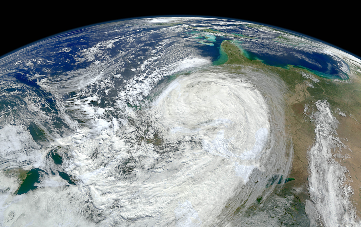
Sandy in 2012 was an interesting learning experience. I’d always joked, “Is it possible to get a snow-cane? To have a hurricane that would have snow with it?” Well, Sandy showed us that it could happen. In West Virginia, on the upslope side of the westerly wind, they had quite the snowstorm associated with Sandy.
Some research I did showed that each time Sandy interacted with a trough it got stronger and bigger. Not as a hurricane per se, but the storm expanded in area as it interacted with more environments that were governed by temperature contrasts outside the tropics.
Sometimes we’re prisoners of our definitions. Sandy technically was not a hurricane at landfall. It looked like a midlatitude storm, except in the center, there was a kernel of an old tropical system, and it had the winds to go along with it. So, what was that?
Well, the insurance companies said it didn’t meet the definition of a hurricane. The practical significance of what it was is still playing out in the courts, because the insurance companies were trying to wiggle out of having to pay for home repairs and building repairs. Their argument is, “Wait a minute, we cover hurricanes; we don’t cover midlatitude cyclones.” It’s an argument that only lawyers can love.
These definitions are not as clean as you sometimes would like them to be. It’s not like turning a light switch on and off, now suddenly a hurricane is a midlatitude storm.

Image created by Norman Kuring, NASA/GSFC/OBPG.
What were some of the difficulties with predicting Superstorm Sandy?
The challenge with Sandy was the big forecast. There was the big debate about the European Center model, which showed a more westward track of the disturbance, whereas the American model showed more of an eastward track but also had things going to the west. The European model, fairly or unfairly, got a lot more credit in the media for catching on sooner that Sandy was going to do that famous left hook toward the coast.
There has been a lot of discussion about that forecast, but the effect of Sandy was the Sandy Supplemental Bill, out of which NOAA [the National Oceanic and Atmospheric Administration] got about $50 million to improve the National Center of Environmental Prediction.
Weather forecasting accuracy has improved significantly over the past 30 years. What are the main factors behind this change?
Most of the credit has to go to increased observations derived from satellites, increased understanding of the dynamical and thermodynamical processes that govern weather, and the tremendous advances in numerical weather prediction from the global forecast models. By far that is the most critical process.
A lot of people work very hard to get these global forecast models to work. They assimilate all the data from observations everywhere around the globe, all different kinds of observations— from the surface, from radio site launches, from balloons, from aircraft, from satellite-derived measurements— and put them together into something that the model can recognize as an initial condition, which you can start integrating forward.
That’s a very sophisticated process to run these global models. But without that, we would not be making these advances. The future of forecasting is in the ensemble forecast, the probabilistic forecast. But that said, there’s still a long way to go. As anybody who’s had a busted forecast knows.
What is ensemble forecasting, and how does it work?
If you have a model forecast, you can do two things: You can perturb the physics or you can perturb the initial conditions. If you adjust either of these a little bit and then run the forecast, each forecast will differ because you changed the initial conditions of temperature, moisture in the atmosphere, or wind in the atmosphere. Or you changed how you specified the physics of precipitation.
To make an ensemble or probablistic forecast, you have, say, an ensemble with 100 different members at a specific point, such as Atlanta, Georgia. Sixty of those members predict a quarter inch or more of precipitation, and 40 of the members predict nothing. Probabilistically, 60 out of 100 members of the ensemble are forecasting rain, so you’d have a 60 percent probability.
I know a lot of members of the public who say, “we don’t understand probabilities,” and I always laugh because the same people will talk about their horse going off at 5 to 2 at their local track, and they understand completely what it means to bet money on a gambler’s odds. So, my tongue-in-cheek suggestion is to start a weather lottery, where you put money on it, and then the public will pay attention and understand completely what a 30 percent chance of rain means.
Where do you think the field of meteorology is headed next?
There is so much money to be made if you could make a skillful week 2, week 3, or week 4 forecast of temperature and rainfall anomalies. We’re not going to be able to say, at least in the foreseeable future, whether 20 days from now it’s going to be sunny or rainy as a specific forecast. But I like to think that fairly soon we might be able to say 20 days ahead of time that the probability is more likely than not that temperatures will be above normal and rainfall will be below normal.
Businesses really want to know that. Shipping companies want to know, for example, that it’s going to be tropically inactive for the next three, four, or five weeks. If you’re trying to organize optimum routes and you know that the Atlantic is going to be quiet but the Pacific is going to be very active for the next three to five weeks, that’s going to matter because more and more businesses are global.
People who just tweak the statistical forecast of high and low temperatures— increasingly that kind of job is going to be done by computers. What’s really needed are people who can oversee what’s going on, who understand and can interpret what the numerical forecast models are saying, and who can advise a wide variety of clients in the public and private sectors about what to expect and why, from the point of view of the global weather connections.

American Scientist Comments and Discussion
To discuss our articles or comment on them, please share them and tag American Scientist on social media platforms. Here are links to our profiles on Twitter, Facebook, and LinkedIn.
If we re-share your post, we will moderate comments/discussion following our comments policy.