This Article From Issue
January-February 2012
Volume 100, Number 1
Page 66
DOI: 10.1511/2012.94.66
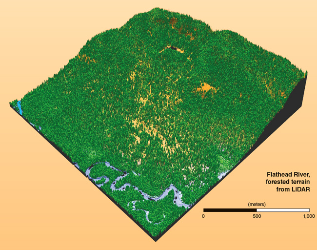
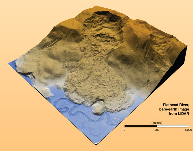
The vegetation covering much of Earth makes it tough to survey the planet’s surface from above. In other words, it’s difficult to see the ground-level features for the trees. Airborne light detection and ranging (LiDAR) technology has changed that. Combining laser surveying instruments and GPS, researchers make bare-Earth maps of thousands of square kilometers with decimeter resolution. William E. Carter cofounded the National Center for Airborne Laser Mapping, which is funded by the National Science Foundation and operated by the University of Houston and the University of California, Berkeley. Carter discussed the promise of the technology with American Scientist associate editor Catherine Clabby.

A.S. What are the building blocks of airborne LiDAR?
W.C. The primary components include a laser that is compact and diode pumped and that pulses tens of thousands of times per second for very short periods—only a few nanoseconds. An optical scanner, an inertial measurement unit containing laser gyroscopes and solid-state accelerometers, and a geodetic-quality Global Positioning System (GPS) receiver are also needed. So are high-speed electronics for operational control, data collection and storage, and processing. All this allows us to determine the location and orientation of an aircraft relative to a well-defined geodetic reference frame, and to measure the lengths and directions of vectors from the airborne sensor to closely spaced points on reflecting surfaces of what is scanned. Postflight filtering of the raw, laser-point clouds allows the returns to be grouped into categories such as vegetation, buildings or ground. The ground points can then be interpolated to form an equally spaced “bare earth” digital elevation model (DEM). Computer programs translate DEMs into shaded relief images, 3-D perspective images, contour maps and surface profiles.

A.S. Why can these systems “see” aspects of the surface that photography cannot?
W.C. Aircraft collecting research quality airborne LiDAR observations typically fly at altitudes of hundreds of meters and speeds of 70 to 90 meters per second. An aircraft will typically have moved only a few millimeters during the round-trip travel time (4 to 8 microseconds) of the laser pulse. That allows the transmitted and reflected laser pulses of light to travel along essentially identical paths to and from the aircraft. The number of photons from the laser striking a spot on the ground can be many times that arriving from the Sun. Temporal, spatial and spectral filters are used to suppress any background noise from the Sun or artificial light. In simple photography, sunlight must pass through an opening in the vegetation to reach a specific spot on the ground, and the reflected light must pass through a different opening in the vegetation to reach the aircraft. To make the stereo pairs of photographs required to obtain 3-D coordinates of points, light must find four open paths through the vegetation, two for the first picture and two more some time later when the second is taken. The problem is made even worse because the altitude of the Sun is often well below 60 degrees. This results in longer path lengths through the vegetation and lowers the chances of open pathways.
A.S. Can you give a couple of examples of new insights gained from LiDAR imaging?
W.C. With pulse rates of 75,000 to 150,000 pulses per second, resulting in point densities of 6 to 12 pulses per square meter, it is now possible to map archaeological ruins hidden beneath tropical rain forests. Archeologists Arlen Chase and Diane Chase of the University of Central Florida have been working at the ancient Mayan settlement of Caracol in Belize for more than two decades. With LiDAR data, they found that the agricultural terraces were far more extensive than they had been aware of and that there were remains of many more structures hidden in the dense tropical rain forest than they had discovered on foot. This increased the estimates of the number of Mayans who lived at Caracol and improved understanding of its importance in Mayan history.
Using LiDAR data collected along the Eel River in northern California, Ben Mackey of the California Institute of Technology and his University of Oregon colleagues discovered where a large landslide dammed the river some 22,500 years ago, creating a lake that dramatically reduced the transport of eroded material downstream and into the ocean. The dam also limited the annual run of fish up the river during breeding season, which likely resulted in the intermixing of two varieties of trout, resulting in a new variety peculiar to the area.
A.S. What sort of future applications do you expect?
W.C. Airborne LiDAR is still in its early stages of development. After improving pulse rates by a factor of 20 to 40 over the past decade, the field is now trying to develop systems with two or more color lasers. Fiber-optic lasers promise to make multicolor airborne LiDAR units feasible in the next few years, opening up new areas such as identifying the types and health of vegetation, identifying surface soils and minerals, estimating the soil moisture, and measuring and evaluating the health of animals such as migrating whales.
It is difficult for LiDAR units aboard small, piloted aircraft to respond rapidly to natural and human-made disasters such as flooding, earthquakes, hurricanes and oil spills. Smaller, lighter and less power-consuming LiDAR units are needed to allow quick deployment in low-flying unmanned aerial vehicles (UAVs). Systems capable of mapping from large UAVs operating above commercial airspace with flight durations of several days to weeks are also needed. Such units would have made it possible to deploy LiDAR to Haiti after the 2010 earthquake. An aircraft could have lingered for days, collecting quantitative information on damage to assist response teams, without requiring local support such as airport space, fuel, living facilities for a pilot, or ground-support staff.
In Sightings, American Scientist publishes examples of innovative scientific imaging from diverse research fields.
American Scientist Comments and Discussion
To discuss our articles or comment on them, please share them and tag American Scientist on social media platforms. Here are links to our profiles on Twitter, Facebook, and LinkedIn.
If we re-share your post, we will moderate comments/discussion following our comments policy.