All Cells Lead to Rome
By Michelle Hoffman
Patriotic pancreas cells form a map of Italy
Patriotic pancreas cells form a map of Italy

DOI: 10.1511/2000.35.0
Scientists are citizens too. A patriotic biologist might be excused for choosing national colors for banding birds or staining tissue, and Antarctic explorers are expected to plant their countries' flags at the South Pole. Still, what happened in Italian cell biologist Lelio Orci's lab went a step further. And Orci insists that it was an accident.
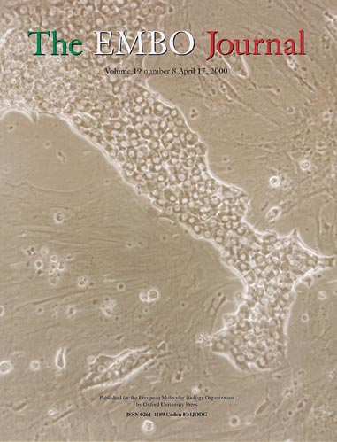
Permission courtesy The EMBO Journal and Oxford University Press
For over 30 years Orci, head of the Department of Morphology at the University of Geneva Medical School in Geneva, Switzerland, has been studying, among other things, the hormone-secreting endocrine cells of the pancreas. To do that, he first isolates the endocrine cells from newborn rat pancreases and places them in petri dishes containing culture medium, where they cluster together in aggregates.
In all his years surveying the dishes under the microscope, Orci has noticed a great variety of shapes among the aggregates. Remarkably, one of the shapes to arise spontaneously was this map of the experimenter's own peninsular nation—complete with the island of Sicily off its coast. (Sicily appears to be truncated somewhat, which Orci playfully suggests is the result of a cloud passing overhead.)
Orci is an accomplished artist whose spectacular watercolors often grace the cover of The EMBO Journal, the journal of the European Molecular Biology Organization. When the editor recently asked Orci for another interesting cover image, he offered her a photograph of the event he witnessed under his microscope. The journal then upped the ante by using the colors of Italy's flag for the journal's logo.
Have other maps ever appeared in his petri dish? Yes, Orci says. He has an image of Switzerland as well, but he'll leave it to a Swiss national to "discover" his or her own microscopic country.—Michelle Hoffman
Click "American Scientist" to access home page
American Scientist Comments and Discussion
To discuss our articles or comment on them, please share them and tag American Scientist on social media platforms. Here are links to our profiles on Twitter, Facebook, and LinkedIn.
If we re-share your post, we will moderate comments/discussion following our comments policy.